Project: 8.3.2
Effect of fire severity on the response of populations of priority wildlife species
Project Leaders: Sarah Legge , Hayley Geyle , Stephen Garnett , Libby Rumpff , Nick Whiterod , Dale Nimmo , John Woinarski , Ben Scheele , Darren Southwell , Michelle Ward
Research in brief
The Wildlife and Threatened Species Bushfire Recovery Expert Panel carried out a rapid assessment of vertebrate species (and some invertebrates) most in need of management intervention after the 2019–20 bushfires, based on how imperilled they were before the fires, the extent to which their distribution was burnt, and the species’ vulnerabilities to fire.
In this project, we will build on this assessment by considering spatial variation in fire severity, as well as variation in species’ responses to fires of different severity. Species’ fire responses will be estimated using an expert elicitation process, informed by the collation of data on species traits. The project will also estimate recovery time for fire-affected species, and the extent to which management can accelerate that recovery.
Why is the research needed?
Improving estimates of fire impact across species helps direct conservation effort where it is most needed to support recovery. Improving our understanding of how species have been affected by fire is also critical for identifying the actions required to support recovery not just following the 2019–20 fires, but after future fire events.
The initial rapid assessment assembled information on physical, behavioural, ecological and life history traits across species to estimate vulnerability to fire. However, trait data was sometimes unknown. In addition, species’ fire response depends on the fire severity, and species respond to variation in fire severity differently. For example, some rainforest species are very sensitive to even low severity fires, while many woodland and dry forest species are reasonably resilient to low severity fire events and respond variously to high severity fires. This species-specific variation in fire response can be estimated using expert elicitation.
The Expert Panel’s rapid assessment used the fire extent maps that were available at the time, which do not account for the variation in fire severity within and across firescars. Fire severity mapping at a national scale has since been undertaken by the Department of Agriculture, Water and the Environment (DAWE) and the New South Wales Department of Planning, Industry and Environment, based on Google Earth Engine Burnt Area Maps. Coupled with taxonomic updates and updated species distribution maps, new spatial analyses of the fire overlaps can now consider the proportions of each species’ distributions that were burnt in fires of varying severity.
How will the research help?
The project involves a spatial analysis and an expert elicitation process, which will be integrated to achieve the project aims:
- Update assessment of the vertebrate species and spiny crayfish species most impacted by the 2019–20 fires, in order to refine list of priority species.
- Estimate time for populations to recover to pre-fire condition, and the extent to which management can accelerate that recovery.
- Identify the species that will, or will not, recover (with and without management) before a future similar fire event.
- Relate expert opinion on species fire response to species traits, to allow readier assessment of fire impacts during future fire events that affect different suits of species.
The project results can also be used to inform conservation assessments, and to feed into other fire-related research being undertaken through NESP.
What research activities are being undertaken?
Updated spatial analysis
We will intersect updated species distribution mapping with the national fire severity map to estimate the proportion of each species’ range that was burnt in fires of varying severity. For aquatic species, we will also consider the impacts from upstream fire events.
Expert elicitation
Considering species traits, pre-fire population status, trend and distribution information, and the post-fire management options, experts will estimate:
- the extent of proportional population decline, after fires of different severity, immediately after fire, in the first year, and out to 10 years or three generations after fire;
- the length of time before fire affected populations recover; and
- the extent to which management actions accelerate that recovery.
Combining the spatial analysis with the expert elicitation
For each species, we will apply the proportional population loss estimates to the proportion of its distribution that was unburnt, and burnt (at each severity class), to get overall population decline. We will use these proportional losses to refine the list of priority species, and inform conservation assessments.
For each species, we will use the time to recovery information (with/without management), with predictions of future fire regimes, to identify the species most vulnerable to future fire impacts, in the context of cooccurring threats (invasive species, drought, fragmentation, etc.).
Across all species, we will look for correspondence between traits and fire response to allow for predictions of fire response in other taxa not included in the expert elicitation.
Who is involved?
This is a collaborative project involving researchers from universities around Australia, consultants, NGOs, state agencies and DAWE.
Where is the research happening?
The project will consist of desktop analysis. The research will apply across all fire-affected regions of south-eastern and south-western Australia.
When is the research happening?
The project will run from January 2020 to April 2021.
More Information
For more information please contact:
Sarah Legge SarahMariaLegge@gmail.com
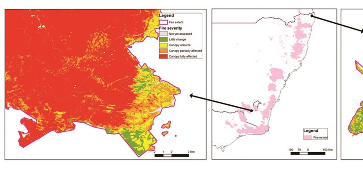
Top image: Example of the variation in fire severity, as measured by the degree of canopy damage, within and across firescars. These examples (left and right maps) are both from NSW, to the same scale, with their locations shown in the middle map. Data on the firescar boundary is from the National Indicative Aggregated Fire Extent Dataset, which has variable resolution. The fire severity mapping is from the Australian Google Earth Engine Burnt Area Map (AUS GEEBAM), with 40 m resolution.
-
From the ashes: The 2019–20 wildfires and biodiversity loss and recovery
Monday, 31 August 2020 -
Rapid action to save species after the fires
Monday, 31 August 2020 -
Prioritising action for animal species after the fires
Tuesday, 01 September 2020 -
Protecting persistence: Listing species after the fires
Tuesday, 01 September 2020