Project: 8.1.1
Designing rapid on-ground reconnaissance surveys for post natural disaster (fire) to assess the status of species, ecological communities, habitats and threats
Project Leaders: Darren Southwell
Research in Brief
The 2019–20 bushfires were unprecedented in terms of their scale, intensity and timing. On-ground reconnaissance surveys are crucial for assessing the impact of the fires on native species. This project conducted a gap analysis of post-fire surveys across Australia for federally listed priority vertebrates. It aimed to predict the pre-fire distribution of priority species, and combine this information with remotely sensed fire severity maps and information on existing survey efforts to prioritise new survey locations. This project also reviewed design considerations for post-fire surveys with a focus on priority listed species.
Why is the research needed?
On-ground surveys are a crucial first step to assessing the immediate impact of the fires and for prioritising management to aid population recoveries. Post-fire surveys are underway in many parts of Australia; however, it is unclear whether existing survey efforts are representative of the species listed as most vulnerable to the fires. By combining species distribution models, fire severity maps and information on existing surveys in a spatial gap analysis, this project will most efficiently identify new areas for surveys to improve the representation of priority species. Our analysis is crucial for deciding whether additional surveys are needed, what species they should target, and where in the landscape they should be established to most efficiently fill these gaps. How will the research help? This project conducted a gap analysis of post-fire surveys across Australia for federally listed priority vertebrates. It aimed to predict the pre-fire distribution of priority species, and combine this information with remotely sensed fire severity maps and information on existing sampling effort to identify new areas for surveys. Specifically, the project set out to determine:
- where to prioritise new survey sites within burnt and unburnt areas to better understand the current status of priority listed species, while accounting for current survey efforts already underway
- the preferred detection method(s) for priority listed vertebrates
- minimum survey requirements for priority vertebrates (where possible).
The project determined where to position survey sites within burnt and unburnt areas to better understand the current status of priority species. Importantly, it accounted (where possible) for surveys already underway to avoid duplication of existing efforts. Where possible, recommendations were made about how much effort should be invested in surveys to have a good chance at detecting surviving populations.
This project is the first phase of a fuller NESP Threatened Species Recovery Hub project focused on mid- to long-term monitoring of priority species (Project 8.1.2) The project has also been extended to include a spatial prioritisation for priority listed plants and invertebrates. This in turn will feed into other hub projects on monitoring, including Project 7.5 “National monitoring priorities, process and prospectus for threatened species”. Species distribution modelling work will underpin a wide range of post-fire research within and beyond the NESP Threatened Species Recovery Hub. Species distribution models developed for invertebrates will be linked to Project 8.3.1 “Fire-affected invertebrates: Priority species and management response” and Project 8.3.3 “Genetic assessment of priority taxa and management priorities”.
What research activities are being undertaken?
The first major task of this project was to engage with agencies managing fire affected regions to:
- Obtain a list of priority species, ecological communities and threats.
- Identify monitoring programs that were operating before the 2019–20 fires for priority species in and around burnt areas, as well as post-fire survey efforts already underway.
- Identify the most appropriate survey method(s) for priority species, ecological communities and threats.
- Obtain up-to-date digital maps of fire extent and severity.
- Develop and/or obtain species distribution models for priority listed vertebrates, plants and invertebrates as well as threatened ecological communities. The second task was to design rapid post-fire reconnaissance surveys to assess the status of priority species, ecological communities, habitat and threats. In this component of the project:
- Priority regions for new vertebrate surveys were identified in a spatial analysis that combined the species distribution models with fire severity maps. The spatial analysis will accounted for postfire surveys already underway and ensured adequate representation across species;
- Habitat refugia will be identified within burnt regions to inform post-fire management;
- The minimum survey effort needed to detect priority vertebrates was determined given the most appropriate survey method(s) and estimates of detectability (where possible);
- Guidance on how to measure fire severity, habitat condition and threats during post-fire reconnaissance surveys was provided.
Who is involved?
The project team of University of Melbourne researchers partnered with state and territory governments affected by the 2019–20 wildfires, Birdlife Australia and the Wildlife and Threatened Species Bushfire Recovery Expert Panel.
Where is the research happening?
The project covered fire-affected species in fire-affected areas of South Australia, Western Australia, New South Wales, Victoria, the Australian Capital Territory and Queensland.
When is the research happening?
The project ran from March 2020 to June 2021 (plants and invertebrates ongoing).
Further Information
For more information please contact:
Darren Southwell darren.southwell@unimelb.edu.au
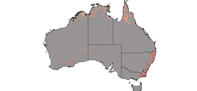
Top image:Fire severity map for the 2019–20 bushfires. Light red = low fire intensity; dark red = highest fire severity. Map: Darren Southwell.